Discovering the Adventures of "Benchmark" Hunting
Share
NGS Survey Markers and Benchmarking?

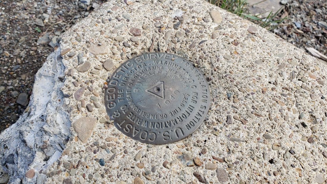
Several years ago while out exploring an old decommissioned forest station lookout tower, I came across an interesting concrete block with an official-looking stamped metal disc embedded in it. I thought, WOW, this is pretty cool! and wondered how many of these were around. So, when I got back home, I started doing a little research and found that what I had discovered is called a "Survey Marker". Since then it's lead me onto multiple adventures to some of the most beautiful places and views imaginable.
History behind Survey Markers

Survey markers, also called survey marks, survey monuments, or geodetic marks, are objects placed to mark key survey points on the Earth's surface. They are used in geodetic and land surveying. A benchmark is a type of survey marker that indicates elevation (vertical position). Horizontal position markers used for triangulation are also known as triangulation stations. Many survey markers in the U.S. were set over 100 years ago. There was a surge in creating these marks in the U.S. from about 1930 to 1955, correlating with the expansion of map-making activities across the country at period. The majority of marks were set by the United States Geological Survey (USGS), the United States Forest Service, and United States Army Corps of Engineers.
"Benchmarking" is the hobby of "hunting" for these markers.

It turns out that there is a popular and fun hobby aimed at finding these markers. Benchmark hunting, as it is often called, involves searching for and documenting survey markers. Enthusiasts use various tools and techniques to locate benchmarks, such as compasses, GPS devices, topographic maps, and online databases. It's a thrilling adventure that combines outdoor exploration with the excitement of treasure hunting. Benchmark hunting offers a unique way to explore the outdoors and discover hidden treasures. It allows you to connect with history and gain a deeper understanding of the land around you. By finding and documenting survey markers, you become part of a community of enthusiasts who share a passion for exploration and discovery.
Getting Started

In the U.S., there are about 740,000 benchmarks in existence, however only a small fraction of the existing survey marks are currently recorded. The National Geodetic Survey (NGS) maintains a database of markers which is accessible online: https://geodesy.noaa.gov/datasheets/ngs_map/
In addition to the survey data sheet for a target mark in your area, many hunters bring along a digital camera to take close-up and area pictures of the survey mark the marks can be in a variety of forms such a stamped metal disk, a simple cross-cut in a rock, an old copper bolt, etc. Taking photographs not only memorializes your adventure, but you can then be upload to a website as proof of a find, along with a description of your find. Surveyors use the term "recovering" as a synonym for "finding" a mark. This does not mean that the found mark should be disturbed in any way. On the contrary—disturbing a survey mark in even a small way often destroys its usefulness to surveyors and others. In the U.S., benchmark hunters often file two different reports on marks they find. One, less formal, is made to the website at Geocaching.com. The other more formal type is made by more experienced and careful hunters to the NGS database itself and describes the mark's found/not found status, current condition, and updated directions to reach it so that others (particularly surveyors) can more easily re-find the mark.
Handheld GPS receivers are often used to get within a few yards of a mark but you may still need to do a little searching as they can get buried under weeds or other debris of time. Many marks are set on the surface of sidewalks, buildings, walls, boulders, or monuments and can often be found without the need for special tools. Experienced Benchmark hunters also frequently carry a compass (to follow directions gleaned from the datasheet), a probe (like a long-bladed screwdriver) to search for buried marks, a trowel (or a small shovel) to uncover buried marks, and a whisk broom to clear away debris.
Before you begin your benchmark hunting journey, familiarize yourself with the basics. Learn how to read topographic maps and understand the symbols used to represent benchmarks. Research the history of benchmarking in your area to gain insights into potential locations. Once you're equipped with the necessary tools and knowledge, it's time to hit the trails. Explore parks, forests, and other outdoor areas known to have survey markers. Use your GPS device to navigate to the coordinates of potential benchmarks. Keep an eye out for any signs or clues that might lead you to a hidden treasure. As you find benchmarks, document your discoveries. Take photographs of the markers and their surroundings. Note down the coordinates, elevation, and any other relevant information. Share your findings with the benchmark hunting community to contribute to the collective knowledge.
Join the Benchmark Hunting Community

Benchmark hunting is not just a solitary activity. There are numerous online communities and forums where enthusiasts share their experiences, tips, and discoveries. Joining these communities allows you to connect with like-minded individuals, learn from their expertise, and expand your benchmark hunting horizons. By searching for and documenting survey markers, you become part of a community of enthusiasts who share a passion for exploration and discovery. So, grab your GPS, compass and topographic maps, and embark on an unforgettable benchmark hunting adventure!
